Dasklip Pass is one of the two sites (the other being Leeuwenkop) referred to collectively as ‘Porterville‘. Hardy scrub covers the dry and rocky mountain range. In summer, the fields below are barren brown and black, having yielded their grains to the yearly harvest. Ground temperatures can soar well above 30deg causing good thermal activity and height gains. The front ridge offers an easy start to big XC flying, with the Cedarberg Range towering behind it to the east. It is dry and dusty on the ground, but once airborne you’ll appreciate the beauty of the land. Wild, untamed mountains and plains with unlimited landing areas stretching out from the foothills to the western horizon. Hidden, inaccessible valleys; blue skies above with strong thermals.
Weather
Porterville averages at least four good flying days a week between November and March. If you know how to thermal, 20km XC is an easy goal.
- North West (NW) to South West (SW)
- South Easterly (SE)
- In winter (June – Sept), just after a cold front, you’ll find gentle thermic conditions over a much greener landscape.
Geography
- GPS: +- S32o54.307’ E19o02.301’
- Altitude: 450m high (700m ASL)
- Airspace ceiling: 2900m (ASL).
Launch
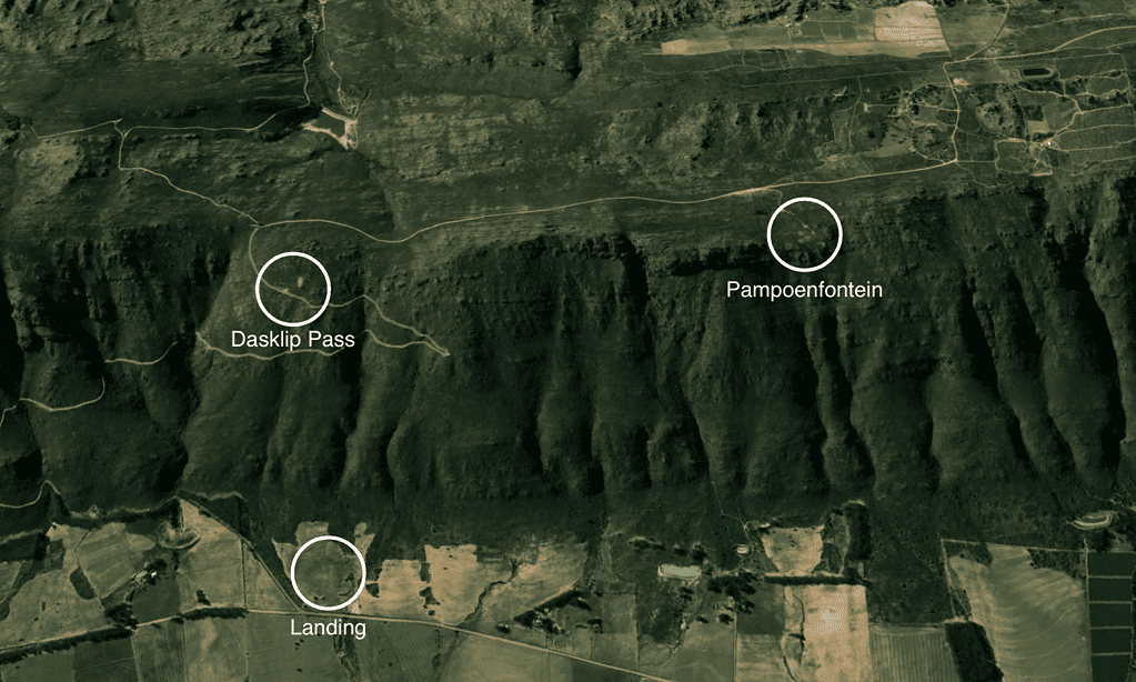
At the top of the Pass is a hangglider ramp and a cut-away for turning your vehicle. The launch is covered with shade-netting, and is just above the road.
Landing
Turkey patch is directly below takeoff, around the Y junction at the base of the pass. The fields on the W and SE of the junction belong to Mr Du Bois, a friendly farmer who lives in the first farmhouse to the S. The triangular field to the NE is only to be used if there is no livestock in it. Close all gates that you open, don’t damage the fences, and please avoid livestock. The two farms to the north of the pass, against the ridge, can be unwelcoming to pilots, so avoid landing near the homesteads. Don’t bring your recovery vehicles onto their private land.
Cautions
In summer, experienced guidance is highly recommended. Make sure that you check the wind-direction around the back of the mountain. Sometimes the takeoff site is in the lee of a strong south-easter, and flying is not recommended until the heat of the valley has raised the inversion high above the ridge. By afternoon the wind is usually southerly, causing a strong rotor (directly in front of takeoff) off the spine to the left. The gully to the right of takeoff causes a strong venturi – don’t venture deeply into it with a slow glider in a strong SW. The glide back to the turkey patch will become difficult, with the ridge causing sinking air, and your glider battling to penetrate.
Directions
Take the N1, then turn left onto the N7 and drive for 100km to Piketberg. At Piketberg, turn right towards Porterville. Turn right at the T-junction and drive into town. Manzoni’s B&B is the third house on the right. When you’re ready to fly, head out of Porterville again, passing the T-junction and continuing north. The first turning right is signposted ‘Cardouw / Dasklip Pass’. After following this gravel road for 10km, you’ll reach the base of the tarred pass. If you are going to park here to catch a ride up with friends, please ensure that your vehicle is well off the road (up against the fence), as the locals complain if we constrict the dangerous intersection. When you reach the top, you will see a hangglider ramp on your left. The paragliding launch site is above the road. Please do not park your vehicle here, or on the left (valley side) of the road, as this causes erosion and traffic congestion, or in the cut-away area where the hanggliders rig and vehicles turn. Park your vehicle on the mountain side of the road on the far side of the cutaway, facing downhill. Leave your keys hidden on it so it can be driven down later.
Permission
Site fee payable to land owner Rob Manzoni (082 788 4398).