Hermanus is a thermic and soaring site with a long ridge. This site is popular for training thanks to its mild, consistent conditions.

Requirements
- Valid SAHPA membership.
- Student pilots must be in possession of a Learner Membership.
- Foreign Pilots must be in possession of a Foreign Membership.
Weather
- South (S) to South East (SE)
- iWeathar Station (live)
- WindGuru (prediction)
Geography
- GPS: S34º24.113’ E19º14.576
- Altitude: 235m ASL, with airspace ceiling at 2300m.
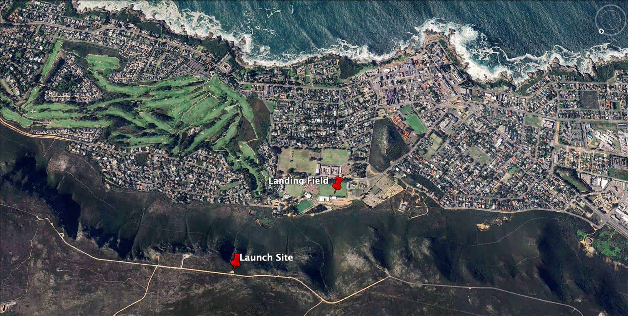
- Launch Location: Paragliding Launch Site, Rotary Way, Hermanus
- Landing Location: Magnolia Street, Hermanus
How to Get There
Take the N2 towards Caledon. After Sir Lowry’s Pass and Houwhoek, you will descend the Houwhoek Pass and see the rolling hills before Caledon. Turn left off the N2 on the R43, signposted Hermanus. After some distance, you enter the outskirts of Hermanus, an area of cottages on the left behind a row of trees. Turn left at the white pillars marked ‘Rotary Way Scenic Route.’ Follow this tar road until it becomes gravel, and continue for about 1km. You will see a signboard beside the road saying ‘Paragliding’ and a concrete launch site overlooking the town of Hermanus and the sea.
Launch
The launch is a clearly-defined concrete slab on the right of the scenic road with benches for spectators. Please confine your launch to the area demarcated by the yellow rocks. Do not launch west of the radio tower.
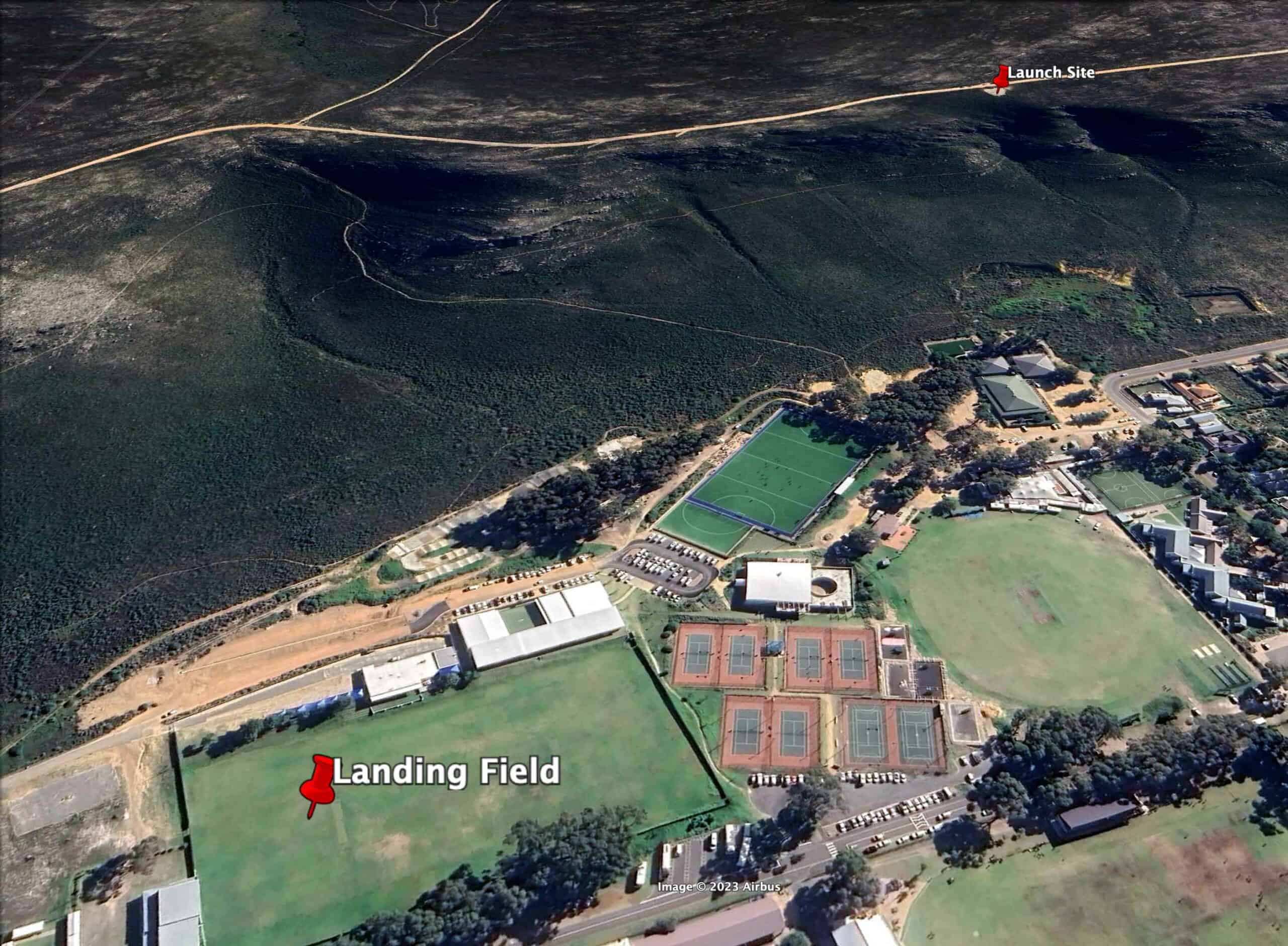
Landing
The bottom landing is below the launch to the right of the tennis courts. Avoid landing on the cricket pitch or pitches (strips of defined hard grass) in the middle areas of the field. Be aware of wind shadow or turbulence caused by the tall trees around the field. When flying with others, bunch your glider and walk to the side of the field before packing. In an emergency, it is possible to slope land at the base of the ridge or in the gravel parking lot next to the field – beware of the low power lines.
The top landing area is across the gravel road, directly behind the launch. To minimize impact, please, only top land directly behind the launch and not to the left or right. Please do not land in front of the gravel road, as this sensitive area is easily eroded and should have as little traffic as possible.
Please do not land on the golf course.
HG landing at the school is often difficult. Top land or land on Grotto Beach.
Cautionary Advice
- Beware of the East wind; it wraps deceptively up the takeoff site but is, in fact, side-on to the ridge and extremely turbulent if moderate to strong. You will find strange holes in the lift caused by the rotor from the big mountains to the east.
- Beware of the South-West wind, which is also very turbulent.
- At the end of the first section of the ridge, to the left of the launch site, is a white trig beacon. This point produces some heavy turbulence if you fly above and behind it – be careful and stay clear and in front.
- When top landing, be careful of crossing low over the ridge, as the edge of the cliff produces rotor turbulence near the front of the ridge, to the left of takeoff.
- Flying to the right of takeoff and crossing the first big gap in the ridge, you will see high-tension powerlines that run down the mountain. They are difficult to see in the afternoon.
- HG: if there is a strong wind on the sea (white horses), don’t top land – go for the beach or the school.